About us
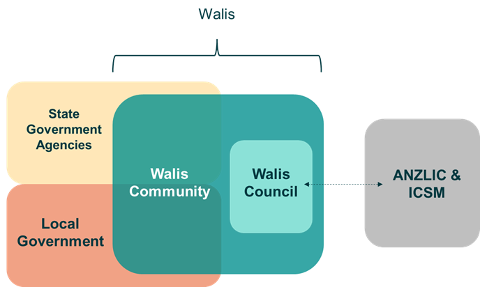
Walis Community
Walis Community is a network of professionals from within the Western Australian (WA) public sector, that regularly access, share, use, and/or create location information and spatial data. The Community includes individuals from various State and Local Government agencies, linking together to share ideas and experiences working with location information. Walis Community members also have access to quarterly online ‘showcase events’.
If you are a member of the public sector with an interest in location information data or policy, please connect with us via LinkedIn or email walis@landgate.wa.gov.au to get involved.
Walis Council
Established in 1981, the Council is a collaborative advisory body, representing the interests of the spatial and location information community of the WA public sector (collectively known as Walis Community).
The primary mission of the Council is to promote good practice and collaboration, making location information both accessible and useful in the decision making and planning of future services for WA.
To this end, the Council works closely with the WA public sector to provide strategic direction and leadership, and to encourage the effective use of spatial and location information in government business. The Council works collaboratively to encourage harmonisation of WA’s location information strategy, policy, and practice with national benchmarks (including collaboration with ANZLIC and ISCM).